
Contact our georepo team to get help with your customized setup.
| Workspaces* | 1 |
| Hosted vector layers | Up to 10 |
| Admin users** | 1 |
| Additional contributors per workspace*** | Up to 4 |
| Supported feature types | Point, Polyline, Polygon |
| Supported import file types | CSV |
| Supported Coordinate Reference System (CRS) | EPSG:4326 (WGS84)**** |
| GeoServer/ PostGIS backend | Yes |
| Web Feature Service (WFS) | Yes (transactional is configurable) |
| Web Map Service (WMS) | Yes |
| API access | Yes |
| Access protection | Yes, Password and API-Key |
| API exchange format | JSON, GeoJSON |
| Bulk update for layers***** | Yes, import CSV automatically, e.g. with cronjob |
| Data export formats | GeoJSON, WFS, WMS, CSV, Shapefile, GML |
| Load layers into GIS clients | Yes, as WFS, WMS or GeoJSON FeatureCollection |
| Georepo App for collaborative layer updates and reviews and building your own geospatial community****** | Optional |
Customized according to your needs, talk to us about your requirements!
Discuss with us to get a discount for your non-profit open data or hobbyist project that addresses societal or environmental challenges.
* A workspace holds different layers with read or write permissions for each user.
** Admin users can review data changes reported by users
*** Contributors can suggest data updates (create, update, delete features)
**** Refers to data import and storage. Layers can be retrieved from WFS or WMS in various CRS.
***** Bulk updates are complete overwrites of a layer with new data and can be automated.
****** Our georepo app can be used as a frontend for georepo.com hosted datasets. Supports desktop and mobile view, installation on the mobile, user registration and collaboration on vector data layer editing and many more individual features.
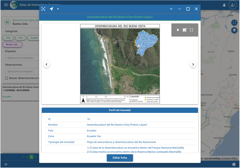
The Atlas of the Wetlands of the South-American Pacific coast (‘Atlas de Humedales Costeros’) is an interactive application for the community to collect, maintain and share information about the environmentally important coastal wetlands of Ecuador, Peru and Chile. As a resource for locals, researchers and interested individuals, the atlas is an encyclopedia and monitoring tool at the same time.
Georepo hosts its spatial and bird census data, imagery and documents and the georepo app also integrates resources from the iNaturalist API.
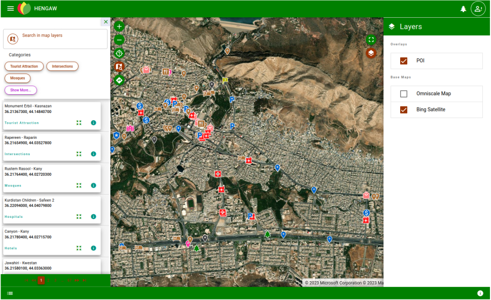
Hengaw.com is a platform for exploring the cities of the Kurdistan region. Users can get information about sights, restaurants or hospitals, navigate to the Points of Interest as well as register to update content and add images.
Yes, point, polyline and polygon layers are supported by the import functionality.
Yes, you can use georepo 30 days for free. Only if you like to continue using georepo, we'll charge you for your subscription.
Yes, your data layers are available as WFS and WMS services.
A subscription period lasts one year.
Georepo is built on proven open source technology like PostGIS and GeoServer. Our georepo app is a Progressive Web App based on Vue.js to support desktop and mobile use cases.
We will invoice you with the subscription fee annually after the subscription started. You can pay by bank transfer or paypal.
Yes. georepo is intended for cross-platform usage and low data exchange barriers. Using the georepo API you can access your datasets as OGC-compliant Web Feature Services, Web Map Services or GeoJSON FeatureCollections from your GIS clients. Apart from that, you can also always download your current datasets e.g. in Shapefile format.
We regret if you don't want to continue using georepo. But we don't want to make it hard for you if you need to leave. Just let us know by email before your next yearly subscription starts, that we shouldn't invoice you further. We'd be happy though, if you send us a hint, what the reason for your cancellation is.
Yes, that's a perfectly valid use case that georepo can support. You can add additional users to your subscription, so they can sign up to your workspace. Best would be if you get in touch so we can make sure you will get the setup you have in mind.
Yes, sure. We'd be happy to check your use case and find a solution for your individual project.